
Analysis of data shows where cycling is most dangerous
There is now a new method for identifying the places and stretches in the city that are most dangerous for cyclists. The method is based on data comparison of travel routes and accident locations. The analysis provides information on which places need to be remedied to reduce the number of accidents.
About half of all road users in Sweden who are seriously injured are cyclists. Most accidents are single accidents, meaning only one person was involved, or accidents where cyclists are hit by a motor vehicle. Despite Sweden’s Vision Zero project, currently there is a lack of systematic efforts to reduce accidents involving cyclists.
“Today we have good information about where most accidents involving cyclists occur, but often these are the places with heavy bicycle traffic. What is equally important to know is which places are most dangerous relative to the amount of bicycle traffic, for instance, places with less bicycle traffic but where many and/or serious accidents occur. Until now, that information has been unknown,” says Erik Stigell, project manager for the project Where is cycling dangerous? or Var är det farligt att cykla? in Swedish.
Places with the greatest risk
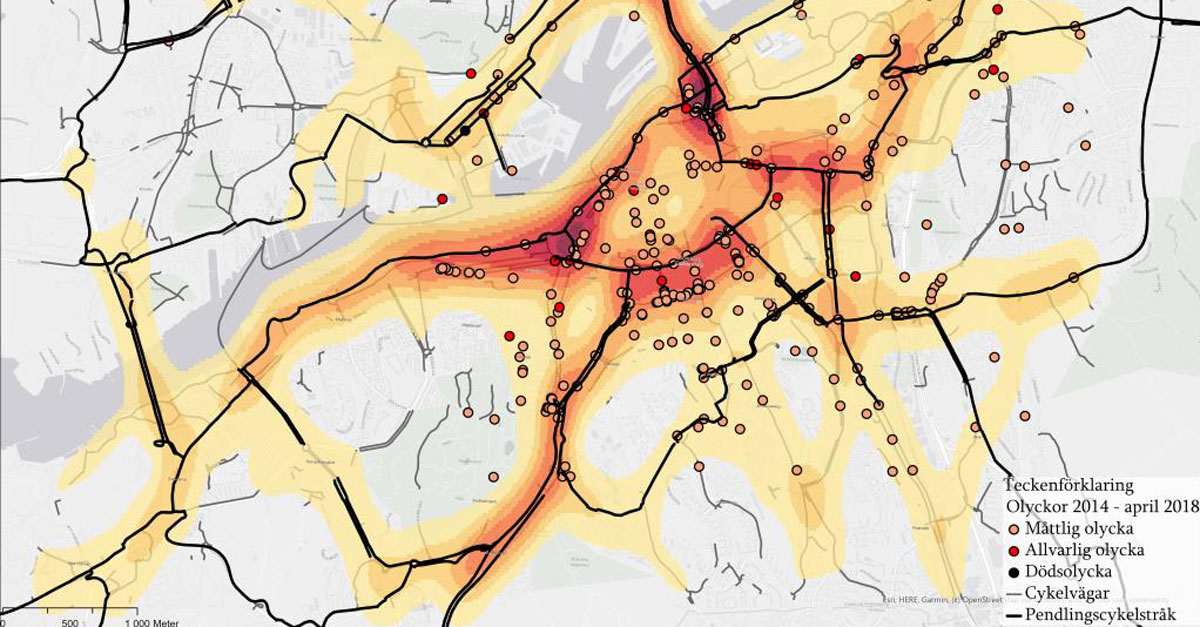
Trivector has now developed a new method that clarifies which places in a city are most dangerous for cyclists and which should be addressed first. The method is based on comparing accident data with data on where people cycle. The method has been tested on data on bicycle trips in Gothenburg, where travel data has been collected via crowd sourcing through the TravelVU app.
“Our method has worked well in the test. It gave a clear picture of which intersections are the most dangerous in Gothenburg,” says Erik Stigell.
Important data is lacking
An initial study of data sources shows that today there are many open and accessible data sources, but that there is also a lack of important data such as how wide the cycle paths are, if pedestrians and cyclists are separated, and if there are fixed obstacles in the roadway. With more data available, the method would provide even better support in road safety work.
This report has been produced with financial support from the Swedish Transport Administration’s Sign Fund (Trafikverkets Skyltfond).
More information
For more information, contact Erik Stigell, project leader ”Var är det farligt att cykla?” +46 10 456 56 79.
Learn more about Surveys, analyses and mapping.